Travel & Leisure Magazine recently designated the Upper James River Trail as one of the best, easy outdoor adventures in the world. Check out their mention of Buchanan, VA!
Nestled within the steep slopes of the Blue Ridge and Alleghany Mountains rests the Town of Buchanan, Virginia. Centrally located halfway between Lexington and Roanoke, the Town’s prime location makes it a perfect stopover for outdoor enthusiasts wanting to take advantage of all of the adventures located in and around the Town of Buchanan.
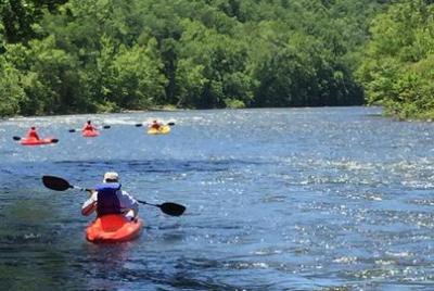
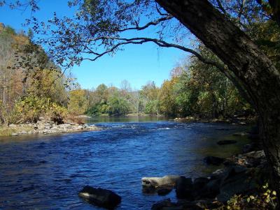
The Town’s natural setting provides ample opportunities for sporting enthusiast to participate in canoeing, kayaking and fishing along the “Scenic James River,” hiking the Appalachian Trail as well as other trails in the National Forests in addition to cycling, mountain bike riding and fishing.
The Award winning Upper James River Water Trail runs right through the heart of town and may be accessed right off of Main Street. The Town’s historic Main Street is just 4 miles from the Blue Ridge Parkway, the Appalachian Trail and the Glenwood Horse Trail. The Town is a short drive from the Spec Mine Trail for mountain bikes as well as Apple Orchard Falls for hikers.
Buchanan’s historic Main Street, US Route 11, coincides with the US Bicentennial Bicycle Trail. The Upper James River Blueway may be accessed off of Main Street at the Town Park on Lowe Street. The Blue Ridge Parkway, the Appalachian Trail and the Glenwood Horse Trail all may be accessed from Main Street by traveling on Parkway Drive while Apple Orchard Falls may be accessed by Route 614, Arcadia Road.
The area surrounding the Town offers numerous opportunities to residents and tourists alike for hunting, fishing, horseback riding, hiking and enjoying the outdoors. Both the Jefferson and George Washington National Forest are nearby and offer many opportunities for camping, hiking and picnicking. Both the Blue Ridge Parkway and Appalachian Trail run along the crest of the mountain and are located just 4 miles from Town.
Appalachian Trail – The Appalachian Trail crosses Route 43 just 4 miles from Buchanan’s historic Main Street. The Appalachian Trail extends more than 2,180 miles from Main to Georgia with a protected 250,000 acre greenway. The Appalachian Trail Conservancy was instrumental in the passage of the federal legislation that designated the A.T. as America’s first national scenic trail in 1968.
The entrance to the Appalachian Trail along Route 43 is just below the ramp onto the Blue Ridge Parkway and offers limited parking. The Town is a rest stop and recharging point for hikers along the trail who use the Town’s U.S. Post Office, Buchanan Library, various shops and restaurants as well as occasionally setting up tents overnight at private homes willing to share accommodations. Often town residents offer shuttle service to hikers to and from the trail. The U.S. Post Office on Main Street has a Hiker Box with food items available to hikers.
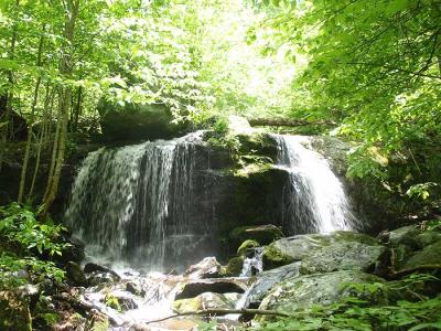
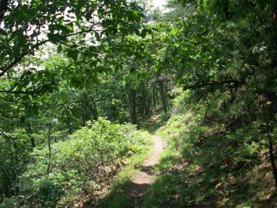
Apple Orchard Falls– Apple Orchard Falls is one of Virginia’s tallest and most spectacular waterfalls. Singing streams, dancing down cascades, huge boulders, and thick stands of forest surround stunning vistas and towering bluff lines. The 7.5-mile loop trail is moderately difficult.
Apple Orchard Mountain was named for the nature of the dominant northern red oak forests on its summits and ridges. The weather is so severe on the upper elevations of the mountain that the trees have taken on a stunted appearance, as if they have been trimmed and pruned over the decades.The Appalachian Trail and the Blue Ridge Parkway pass within a short distance of the top of Apple Orchard Mountain.
Apple Orchard Falls is a moderately difficult, 7.5-mile hike but offers a great waterfall at the end as a reward.
Directions – The Apple Orchard Falls-Cornelius Creek loop is east of Buchanan in the Jefferson National Forest along the western side of the Blue Ridge below the Parkway. Best trailhead access is from the end of Forest Road 59 or from Sunset Field Overlook at milepost 78.7 on the Blue Ridge Parkway. To get to the FR 59 trailhead, take exit 168 off I-81 just north of Buchanan, follow Route 614 just over 3 miles through Arcadia, then turn left at the North Creek Campground sign onto FR 59. In about 4 miles, past the campground, the road will end at a trailhead. The Apple Orchard Falls Trail leads left out of here; the Cornelius Creek Trail is to the right.he Apple Orchard Falls-Cornelius Creek loop is east of Buchanan in the Jefferson National Forest along the western side of the Blue Ridge below the Parkway. Best trailhead
Spec Mine Trail – Found at milepost 96 on Blue Ridge Parkway – This trail circles around Iron Mine Hollow and Spec Mines Branch, above the 19th-century Spec Mines, as it drops 1,300 feet in 2.8 miles to VA 645. Along the way, it passes a large pine tree the Forest Service has posted as a “designated wildlife tree,” not to be cut.
The upper end of Spec Mines Trail is on the western edge of the Blue Ridge Parkway 0.1 mile south of the Montvale Overlook, 50 yards south of milepost 96, and across the parkway from the A.T., 1.7 miles north of Black Horse Gap. The lower trailhead, south of Lithia between Buchanan and Troutville, can be reached by turning east off VA 640 onto VA 645. After 0.4 mile on VA 645, opposite the second (smaller) of two ponds, look for trail sign on right. This is a popular trail for mountain bikers.
Directions – This ride’s general location is 15 miles southwest of Buchanan and just south of Black Horse Gap on the Blue Ridge Parkway. Scenery includes forest roads surrounded by dense woods and awesome views from the Blue Ridge Parkway. This loop will take you across the Blue Ridge Parkway on Old Sweet Springs Road at Black Horse Gap. Almost half of this ride follows the gravel and hard-packed, wide Glenwood Horse Trail, and the rest traverses the Blue Ridge Parkway. Be sure to yield the right of way to horses. Although there are some decent ups and downs, the 21-mile distance is the only limiting factor for less-experienced riders.
Glenwood Horse Trail – Conveniently located at 3022 Pico Road, this trail is just minutes away from downtown Buchanan by way of Parkway Drive. You may also access this trail from the Blue Ridge Parkway at Bobletts Gap. Drop in behind the picnic table at the Bobletts Gap parking lot onto a short trail that takes you to Boblett’s Gap fireroad, also known as Chair Rock Road. Turn right, dropping down exactly 1 mile on a sometimes rocky, sometimes water-holed blast of a 5% downhill.
The singletrack is a hard right that cuts back, and straight up. Keep a close eye out, as the trail is hard to see following a left hand sweeper. Watch your odometer too, more than 1 mile exactly and you missed it. Mineshaft starts as a short, steep 25% gradient before reaching the shelf trail that becomes much more reasonable.
For 5 miles, enjoy a singletrack experience like no other, passing iron ore hollers with mineshafts and holes visible when you hike up the ore piles in certain crevasses of ancient Appalachian mountains.